All Sights
The sights, landmarks, points of interest, entertainment and dining on the Costa Brava. Filter by type and location to quickly find places to visit on the Costa Brava coast.
Coordinates: 42.356649, 2.995690
Phone: 647 74 88 09
E-mail: celler@lavinyeta.es
Contact person: Josep Serra
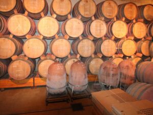
Opening hours: Saturdays 10:00 am to 2:00 pm and 4:00 pm to 7:00 pm, Sundays and holidays 10:00 am to 2:00 pm, other days by appointment only
Winery tour duration: 2 hours
Min group size: 2
Max group size: 30
Languages spoken: Catalan, Spanish, English, French
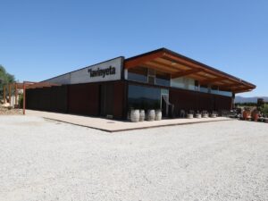

*lavinyeta
42.3566490000, 2.9956900000
Phone: 972 113 443
Adventure Park Platja d'Aro
41.8104120000, 3.0490960000
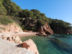
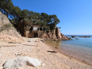
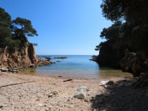
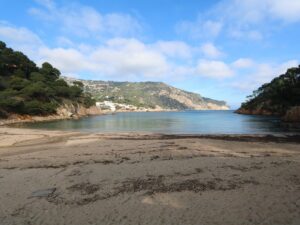
The cove of Aigua Dolça (Cala Aigua Dolça) is a small beach located just a minute’s walk away from the main beach of Tamariu in the central part of the Costa Brava coast.
The Aigua Dolça cove is one of the stops on the map of Vies Braves, a sea swimming lane network created in the Costa Brava in 2014. The cove is 1.2 km away by sea from Cala Aigua Xèlida.
Aigua Dolça Bay
41.9179970000, 3.2095560000

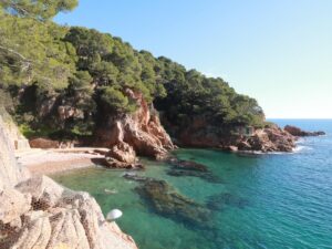
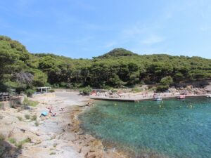
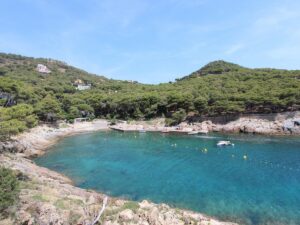
This tiny, hidden yet exceedingly lovely cove of Aigua Xèlida (Cala Aigua Xèlida) is located just by Tamariu, in one of its urbanizations of the same name, in the central part of Costa Brava between Palafrugell and Begur. The sand beach attracts much smaller crowds even at the height of the summer season—most vacationers prefer to sunbathe and swim in Tamariu proper.
The Aigua Xèlida cove is the starting point for one of the Vies Braves sea swimming routes that were created in the Costa Brava in 2014. From here, you can swim to the cove Aigua Dolça.
Directions: Navigation signs towards the cove start appearing on Carrer Enric Morera in Tamariu, so you can enter Carrer Enric Morera, Palafrugell into your GPS navigator.
Aigua Xelida Bay
41.9215000000, 3.2155960000
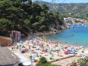
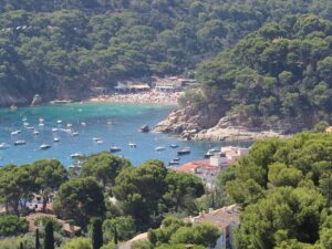
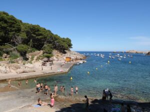
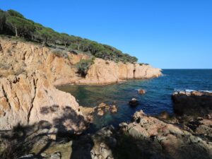
The Aiguablava cove (Cala Aiguablava), the southernmost beach in Begur, is also quite possibly the most populated, not just in the municipality, but in the central region of the Costa Brava coast in general. Partially due to the limited size of its “usable” space (75 m long and 25 m wide), the beach of Aiguablava owes a lion’s share of its popularity to the striking landscape that surrounds it.
“Aiguablava” means “blue water” in Catalan, and it couldn’t be truer here: the sea is crystal-clear and the sand has a golden hue. On the cape Punta d’es Mut to the right stands the only parador hotel in the Costa Brava, a part of the national hotel chain Paradores de Turismo de España. It was built in the 1960s, cementing Aiguablava’s reputation as a luxury destination that was specially chosen to house such an exclusive hotel, giving the owners of nearby villas an easy advantage in the popular debate of which cove or beach is the best in the Costa Brava.
The Aiguablava beach, of course, has obligatory outdoor showers, washrooms and a café at the service of visitors. Parking is also available but it can rarely accommodate everyone, so the curbs of the roads leading down to the beach become spillover, if not strictly legal, parking.
The cape Punta d’es Mut would be of interest not just to tourists but also to archaeologists, as in the mid-20th century, fragments of ceramic cauldrons, glasses and amphorae were discovered here. The cape was home to an ancient Iberian settlement, estimated to peak in the 7th century B.C.
Traces of lively activity may be seen underwater as well. In the vicinity of Aiguablava, which a long time ago had evidently served as a natural port, the specialists of the Centre of Underwater Archaeology of Catalonia (Centre d’Arqueologia Subaquàtica de Catalunya) discovered three shipwrecks that have been resting on the seabed since the 2nd century B.C., the 1st century B.C. and the 2nd century A.D., respectively. The amphorae containing wine and oil discovered among the wrecks became notable museum exhibits, while their copies were thoughtfully arranged in the shallow waters nearby in a nod to numerous divers visiting here.
Aiguablava Beach
41.9341080000, 3.2162190000
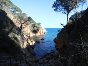
The cove of Aiguafreda (Cala Aiguafreda) is noted on a tourist map of Begur as one of its public beaches, yet in truth, it is a tiny stretch of sand that offers limited space to the visitors wanting to linger here. People coming here to spread a beach towel or lounge on the concrete slabs of a small jetty are plentiful and their desire to hang out is understandable—the views from Cala Aiguafreda are simply fantastic, from the pine forest surrounding the cove and boats gently rocking on the water to the views of cape Cap Sa Sal.
Despite its seeming tranquillity, in the high season, Cala Aiguafreda is bustling with life: rich underwater flora and fauna make the cove one of the most attractive diving destinations in the Costa Brava. Some days, over a hundred dives are registered here! Not surprising, then, to hear beachgoers complain about the hordes of divers descending on the beach in summer, crowding the area and the limited parking spots nearby. It’s quite possible that Cala Aiguafreda will soon see limits placed on the issuance of daily diving permits, as it has already happened on the Medes Islands.

Aiguafreda Cove
41.9645360000, 3.2269940000
Phone: 972 542 020, 972 542 021
Official site
Albanyà Astronomical Observatory
42.3069740000, 2.7107910000
L’Albera is the eastern stretch of the Pyrenees ridge running for about 25 kilometres from the French mountain peak Col du Perthus to the Mediterranean coast. In 1986, the Spanish part of Albera earned the designation of a nature reserve (Paraje Natural de Interés Nacional)—the protected status covers 4207 hectares of land.
L’Albera houses many notable towns and municipalities of L’Alt Empordà, including Cantallops, Espolla, Rabós, Llançà, La Jonquera, Colera, Portbou, and Sant Climent Sescebes.

Albera
42.4038200000, 3.0070700000
Phone: 687 713 231, 685 012 319
Alt Emporda Horse Riding Centre
42.1218010000, 2.9396730000
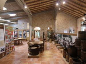
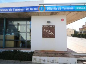
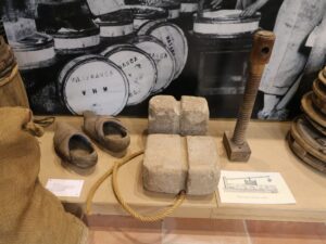
L’Escala is one of the few resorts on the Costa Brava renowned not only for its idyllic beaches and remarkable Roman ruins but also for its delicious food: “anchovies from L’Escala” is a signature regional offering akin to “wine from Priorat”, “prawns from Palamós” and “chickens from Empordà”. No wonder then that the Anchovy and Salt Museum (Museu de l’Anxova i de la Sal) — the only museum in town — is dedicated to fishing and the art of salting and pickling.
The first fishing harbour was built here back in the 16th century to service the needs of fishermen from nearby towns. In 1680, the first stone of a church foundation was laid here, thus giving the small settlement town status. Active fishing and bustling trade helped L’Escala to grow fast — over the course of the 18th century, the town quadrupled in size and became a desirable destination for folk looking for fishing work: many peasants from surrounding regions would abandon their lands, gardens and farms to move to L’Escala and join the ranks of local fishermen.
Until the 1960s, every adult resident of L’Escala either sailed out to sea every morning or salted anchovies and sardines at one of the specialized local factories. Spain was hit with a tourism boom in the sixties, causing the younger generation to reconsider the town-wide business model — many got to work in hospitality instead. Today, the fishing fleet at L’Escala consists of just over fifty fishing boats. The salting factory count is eight; all of them have moved outside the town border so as not to impede the flood of beach vacationers descending on the Costa Brava every summer.
The brand ANCHOA DE L’ESCALA is officially recognized with INDICACIÓN GEOGRÁFICA PROTEGIDA, a system of certificates that are used in Spain to distinguish products of the highest quality with known origins. In the case of L’Escala anchovies, this seal of approval also signals the absence of artificial flavours or preservatives in the tin — the anchovies are salted according to the traditional recipes and techniques.
Visiting the Anchovy and Salt Museum in the Costa Brava would be immensely pleasing to fishing fans and amateur chefs alike. For the former, the museum has an exhibit on fishing techniques, netting and bait, as well as the history of local fishing and the evolution of the fishing trade as a whole. For the latter, traditional salting and pickling recipes are documented, with all the necessary “equipment” — salt, water, paper, wooden and clay containers — readily on display.
Visitor information
Address: Avinguda Francesc Macià, 1 | L’Escala
Phone: +34 972 776 815
E-mail: museu@lescala.cat
Visitor hours:
01.07-31.08: 10:00 am — 1:00 pm (daily), 5:00 — 8:00 pm (Monday to Saturday)
01.09-30.06: 10:00 am — 1:00 pm (Tuesday to Saturday and holiday Mondays)
The museum is closed December 25-26 and January 1 and 6.

Anchovy and Salt Museum
42.1257170000, 3.1261090000