All Sights
The sights, landmarks, points of interest, entertainment and dining on the Costa Brava. Filter by type and location to quickly find places to visit on the Costa Brava coast.
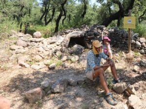
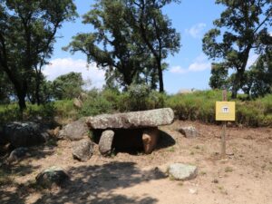
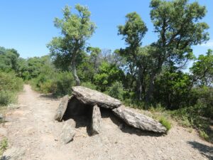
The dolmen of Les Maries (Dolmen de les Maries) owes its name to two Marias from the group of archeologists who dug out the monument from the ground. This megalith appears to have been built between 3000 and 2500 B.C. The dolmen of Les Maries is one of the sights along the megalith route of Santa Coloma de Fitor.
Dolmen of Les Maries
41.9180180000, 3.0862510000
The Mirgoler dolmen (Dolmen del Mirgoler) is one of the dozen megalithic monuments along the hiking route near the village of Capmany that forms part of the Itinerànnia network.
Dolmen of Mirgoler
42.3849610000, 2.9055840000
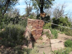
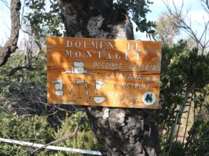
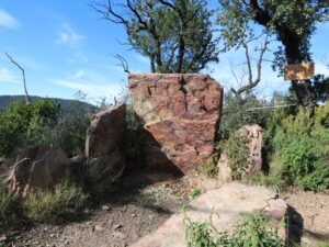
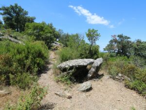
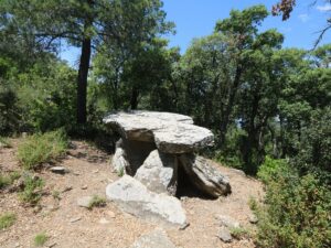
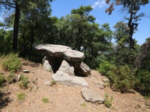
The dolmen (burial chamber) Montagut is located at the peak of the Montagut hill (265 m above sea level) in the mountain range of Les Favarres next to the small town Vall-llobrega.
The dolmen dates back to 2700-2200 B.C. in the Bronze Age. It was discovered during the digging led by archaeologist Maties Pallarés i Gil in 1915-1920. Besides finding the dolmen itself, the team also discovered various fragments of ceramic dishes.
Montagut has the dolmen structure referred to as i>galeria catalana, Catalan Galleria, with lower hallways relative to the chamber height. Montagut’s hallway is U-shaped, made from slate plates, just like the chamber itself. The top horizontal plate and three side ones have been found in their proper positions, while the archaeologists also uncovered the fallen eastern plate and the cracked western one. Beyond the top plate, one can spot the remains of the burial mound inside which the dolmen stood.
Dolmen of Montagut
41.8858060000, 3.1093530000
The Querafumat dolmen (Dolmen del Querafumat) is one of the dozen megalithic monuments along the hiking route near the village of Capmany that forms part of the Itinerànnia network.
Dolmen of Querafumat
42.3909120000, 2.9205850000

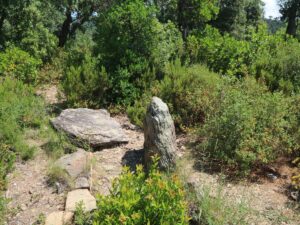
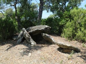
The dolmen Roca de l’Aglà was discovered in 1912 and properly dug out in 1965. It dates back to 3.000-2.500 B.C. The dolmen is one of the megaliths found on the hiking route crossing the Fitor area. Dolmen de la Roca de l’Aglà has two other names—The Small Dolmen (Dolmen Petit) and The Vinyassa Dolmen (Dolmen de la Vinyassa).
Dolmen of Roca de l'Aglà
41.9166960000, 3.0977370000
The dolmen Serra d’en Cals (Dolmen de la Serra d’en Cals) was discovered in 1912 and brought above ground in 1965. Archaeologists date this megalith to 3000-2500 B.C. The dolmen of Serra d’en Cals is located along the thematic hiking route through Fitor.
Dolmen of Serra d'en Cals
41.9190040000, 3.0835750000
The first mention of the dolmen Serra Mitjana (Dolmen de la Serra Mitjana) dates back to the 9th century—an ancient document defining the borders of the village of Sant Climent de Peralta uses the dolmen as a waymark. The digging of the megalith began in 1919, but the attempts to extract it from the ground were for the longest time unsuccessful—only in 1965 did the archaeological team led by Lluís Esteva i Cruañas finish the job. Scientists date the monument back to 3.400-3.200 B.C. The dolmen of Serra Mitjana is one of the landmarks on the archaeologically-themed hiking route in Fitor.
Dolmen of Serra Mitjana
41.9193190000, 3.0943080000
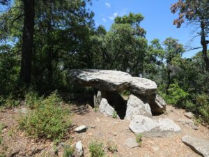
The existence of the dolmen Tres Caires (Dolmen dels Tres Caires) has been known since 1912. The archaeological group led by Catalan historian Lluís Esteva i Cruañas dug the megalith out in 1960s. The monument dates back to 3.000-2.500 B.C.; it’s one of the notable sights along the megalithic hiking route of Fitor.
Dolmen of Tres Caires
41.9185870000, 3.0844000000
The dolmen Tres Peus (Dolmen dels Tres Peus), also known as The Big Rock (Pedra Gran), was first mentioned in a 1881 publication and was successfully retrieved from the ground in 1965. Archaeologists date it back to 3.200-3.000 B.C. The dolmen Tres Peus is a signature sight of the prehistoric hiking route in Fitor.
Dolmen of Tres Peus
41.9187550000, 3.0826320000
Phone: 633 576 272
Donkey Riding Burro Trek
42.3511920000, 3.0659500000
Phone number: 972 250 512
Opening hours (October-March): Tuesday-Friday 10:00 am to 2:00 pm, Saturdays 10:00 am to 2:00 pm and 4:00 pm to 6:00 pm, Sundays 10:30 am to 1:30 pm.
Opening hours (April-June, September): Tuesday-Saturday 10:00 am to 2:00 pm and 4:30 pm to 7:00 pm, Sundays 10:30 am to 1:30 pm.
Opening hours (July-August): every day 10:00 am to 2:00 pm and 5:00 pm to 8:00 pm.
Closed on 1st and 6th January, 3rd week of January, 11th September, 25th and 26th December.
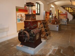
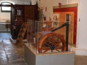
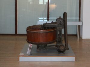
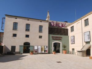
Eco-museum Farinera
42.2588110000, 3.0769660000
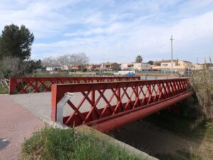
Out of the eight bridges that Gustave Eiffel had engineered for the Girona railway company, the bridge in Colera has an important function of transporting passengers and cargo between Spain and France.
The bridge was erected in 1878 over the ravine where the town of Colera is nestled. During the Spanish Civil war (1936-1939), the bridge was a key strategic site for both sides and, despite numerous seaside and air attacks, has survived thanks to the artillery troops and antiaircraft systems of the Republican forces.
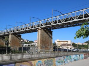
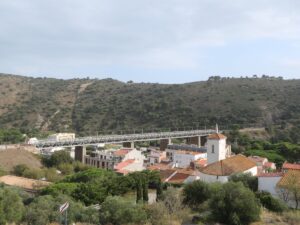
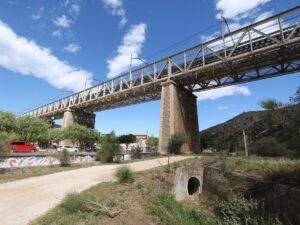
Eiffel's Bridge in Colera
42.4030200000, 3.1527100000
The pedestrian bridge next to Plaça Manuel Josep Iglesias Joan in the neighbourhood Germans Sàbat in Girona is one of eight Eiffel bridges that Gustave Eiffel, of the Eiffel Tower fame, had engineered for the Girona railway company.
In 1876, the bridge was mounted right in the city centre, on the street Carrer Cerverí. As Girona grew, the bridge had also moved around, until it landed on its present spot — a quiet residential area on the outskirts of the city.
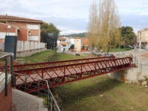
Eiffel's Bridge in Germans Sàbat (Girona)
41.9960030000, 2.8040650000
The Clock Bridge (Pont del Rellotge), laid over the rail tracks in Girona in 1878 between the Devesa park and Avinguda de Ramon Folch, moved to Palamós in 1963 to connect the town centre with the Balitra neighbourhood.
Out of all eight bridges that Gustave Eiffel had engineered for the Girona railway company, the Clock Bridge has travelled the most distance away from its original location — 45 km.
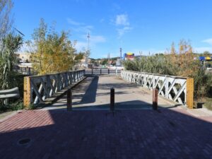
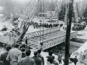
Eiffel's Bridge Pont de Mas Gorgoll
41.8545080000, 3.1190620000