All Sights
The sights, landmarks, points of interest, entertainment and dining on the Costa Brava. Filter by type and location to quickly find places to visit on the Costa Brava coast.
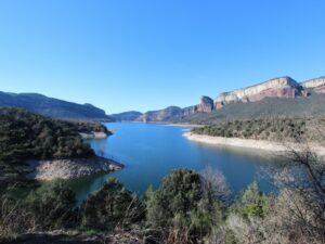
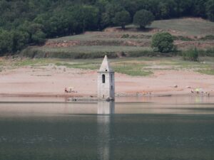
In 1962, several houses, a parish church and a bridge over the river Ter disappeared underwater practically overnight. The construction of the dam to splice the river in two was complete and a new blue splash appeared on the map of Catalonia, known today as the water reservoir Sau (Pantà de Sau).
The first records of the village that was sacrificed for the dam, Sant Romà de Sau, date back to the 10th century. The church was consecrated in 1602. It has been described as built in the Romanesque style, with a nave with an apse and a three-storey belltower. The top floor windows of the belltower were shaped as half-arches. The decoration technique has been identified as Lombardian in origin.
Verifying these statements is only possible in especially draughty years when the water levels of the dam fall so low that it becomes possible to walk the streets of the drowned village. In seasons with average rainfall levels only one to two storeys of the belltower are visible above water.
The Sau reservoir is 17 km long and 3 km wide—its maximum capacity is 151,3 hm3. It’s a popular weekend and vacation spot for lovers of water activities and sports.
Visitor information
Select Vilanova de Sau as the destination for your GPS and follow signs for Embassament de Sau or Pantà de Sau.
If the goal of your visit is to see the submerged church without diving, check the water levels prior to your visit at the official website of the Sau reservoir. The photos appearing here were taken in September 2016 when the levels were at 95 hm3. When they reach 120 hm3, only the very top of the belltower spire is visible.
Hotel Parador de Vic-Sau (4*), part of the national hotel association Paradores de Turismo, occupies an optimal vantage point on a nearby mountain, within hiking distance to the reservoir. The views from every window are fantastic.
Sau Reservoir
41.9680560000, 2.4130530000
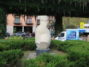
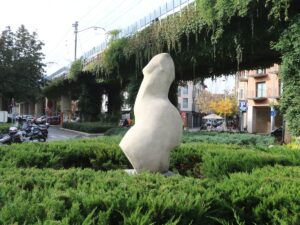
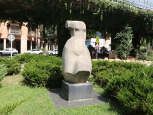
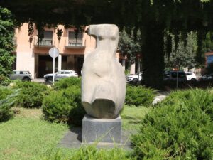
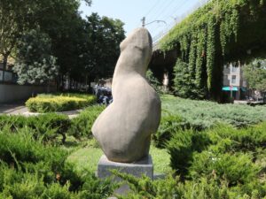
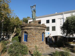
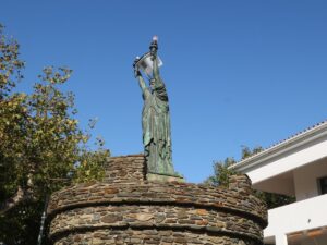
Out of four artworks by the Catalan sculptor Rosa Serra that stand today in Girona, three are dedicated to the subject of female beauty. Without a doubt, ever since Girona received her fantastic statue Tors de dona (The torso of a woman) in 1982, madam Serra has been scrupulous in inspecting her works from every possible angle.
If the sculpture in question was put up in a park, surrounded by hedges and planters somewhat restricting access from undesired angles, the public would likely not notice anything out of the ordinary. However, The Torso of a Woman now stands at the busy intersection of Bonastruc de Porta, Artillers and Figuerola streets, and the passersby walking along the latter would encounter a more unexpected, far from female, form.
Every guidebook for Girona that covers modern art these days makes a note of this, attaching photos that depict the statue from both angles — the obvious and the controversial one. To the credit of the artist herself, she neither denied the resemblance nor claimed that that was the artistic intent all along. A simple coincidence, that’s all.
Sculpture 'Tors de dona'
41.9855890000, 2.8205520000
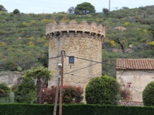


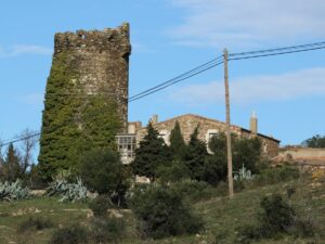
The tower Torre Simona that stands in the small township of the same name in the suburbs of Mont-ras is an observation tower built in the 14th-15th centuries to defend the locals from pirates. It has clearly been a part of a large house that has not survived to this day.
The Simona tower has a stern rectangular structure and an elegant crown with semicircular arches — three on the northern side and four on the eastern and western sides, respectively. The tower is approximately 20 meters tall.
The township inside which Torre Simona is found is fenced off but the gates are always open — as the tower is a protected heritage site, the locals welcome visitors to take a look. (Beware of numerous unleashed dogs, however!)
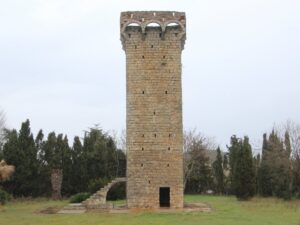
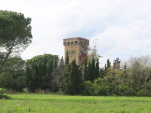
Simona Tower
41.8978080000, 3.1503850000
Coordinates: 41.930720, 3.012738
Phone: 872 00 69 76
E-mail: info@sotaelsangels.com
Winery tour duration: 1 hour
Languages spoken: Catalan, Spanish, English
Sota els Àngels
41.9307200000, 3.0127380000
The 17th-century church of Sant Pere in Begur is notable for its long stone bench running along the side wall of the structure. “No skin off my back, but they would love it” — the church architect, probably. People-watching with a cup of coffee, a glass of wine or beer is one of Spaniards’ favourite pastimes, and the outdoor church bench offers plentiful room to do so.
The Begur bench is called Es Pedrís Llarg, “the long stone” in Catalan, and it is now among the most notable points of interest in town. In a few hours, you will encounter all the locals and town visitors — the church is located dead in the middle of Begur, on the square that connects the streets leading to the town hall, the fortress, the Indianos houses, restaurants and shops.
Thanks to the unknown architect, seniors in Begur (plus, in winter, half of the employment-age folk waiting for the summer season to start) do not need to look for a place to meet, discuss politics, football or local gossip. If you feel the pressure of existential questions weighing down on you, the house of God is right around the corner.
Stone Bench (Es Pedrís Llarg)
41.9544050000, 3.2074230000