Sights of Girona (province)
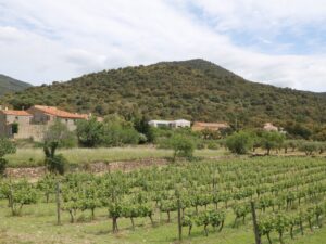
L’Albera is the eastern stretch of the Pyrenees ridge running for about 25 kilometres from the French mountain peak Col du Perthus to the Mediterranean coast. In 1986, the Spanish part of Albera earned the designation of a nature reserve (Paraje Natural de Interés Nacional)—the protected status covers 4207 hectares of land.
L’Albera houses many notable towns and municipalities of L’Alt Empordà, including Cantallops, Espolla, Rabós, Llançà, La Jonquera, Colera, Portbou, and Sant Climent Sescebes.

Albera
42.4038200000, 3.0070700000
Les Cadiretes is a mountain range in the region of El Baix Empordà of the Catalan province of Girona, also known as L’Ardenya. The range adjoins the coast between Tossa de Mar and Sant Feliu de Guíxols and stretches inland toward the border of the comarca El Gironès.
The highest point of Les Cadiretes is the peak of Puig de Cadiretes reaching 519 metres tall.
Cadiretes
41.7736600000, 2.9336300000
Les Gavarres is a mountain range located in El Gironès and El Baix Empordà regions of the Catalan province of Girona.
The nominal borders of Les Gavarres stretch from the town Sant Julià de Ramis in the northwest, through Girona, Cassà de la Selva and Calonge towards Torrent in the southeast, and then onwards towards Fonteta, Sant Sadurní de l’Heura, Madremanya and Celrà.
One of the highest points of the Les Gavarres mountains is the peak of Puig d’Arques which stands 530 metres tall.
Gavarres
41.8895500000, 2.9943700000
Les Guilleries is a mountain range located in the comarcas of Osona and La Selva in Catalonia, nestled between the Plains of Vic (Plana de Vic) to the west, the Anglès municipality to the east, the northern shores of the water reservoirs Sau and Susqueda to the north, and the municipality of Sant Hilari Sacalm to the south. The latter is considered an unofficial capital of Les Guilleries as it’s a major town and even boasts a specialized local history museum.
The tallest point of Les Guilleries is Sant Miquel de Solterra whose peak towers 1204 metres above the sea. Hiking to the top will reward you with the ruins of the Solterra castle and the Saint Michael chapel.
Guilleries
41.9328700000, 2.4927200000
